When you buy a used copy YOU SAVE
0Kg of CO2
0.5 litre(s) of Water
0 Tree(s)
1 book donated to global literacy projects
Hadrian's Wall - Trail Map XT40
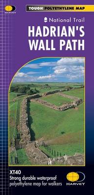
Hadrian's Wall - Trail Map XT40
map
Published:
30 August, 2019
map
Published:
30 August, 2019
Standard worldwide delivery by
Tue, July 7 - Fri, July 10
Order within
0

Condition:
USED
$14.13
RRP
$21.06
You save $6.93 (33%)
Available
1
in stock
FREE Returns within 30 days
Popular Books by Harvey Map Services Ltd.
View All Books by Harvey Map Services Ltd.

Description
Entire route on one map
Hadrian’s Wall Path is a National Trail and runs 130km (81 miles) from the Solway Coast to Newcastle.
The sites of Roman remains are marked on the map, with an enlargement of Housesteads.
Tough, light, durable and 100% waterproof
Includes Rights of Way
Route clearly marked
Hadrian’s Wall Path is a National Trail and runs 130km (81 miles) from the Solway Coast to Newcastle.
The sites of Roman remains are marked on the map, with an enlargement of Housesteads.
Tough, light, durable and 100% waterproof
Includes Rights of Way
Route clearly marked
More Details
| Type | Book |
|---|---|
| ISBN13 | 9781851374380 |
| ISBN10 | 1851374388 |
| Number Of Pages | 1 |
| Item Weight | 30 g |
| Publisher / Reseller | Harvey Map Services Ltd |
| Format | map |
See More +