Thames Path - Trail Map XT60
Thames Path - Trail Map XT60
map
Published:
30 May, 2017
map
Published:
30 May, 2017
Standard worldwide delivery by
Tue, June 16 - Fri, June 19
Order within
0
Popular Books by Harvey Map Services Ltd.
View All Books by Harvey Map Services Ltd.


Description
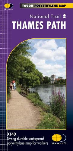
The Thames Path follows the banks of the river for 184 miles (294km) from the flood barrier at Woolwich in South East London to Kemble Gloucestershire. It is a long distance walking route, most of it cannot be cycled. The Trail passes through water meadows, historic towns and lovely villages. The path is flat which makes for easy walking. Jos Joslin National Trails Manager (Marketing & Projects) said of this map, Really beneficial to have the whole length of the Thames Path upstream of London on just one map. Clear mapping and useful information makes this this a very practical map. This map is printed on 100% waterproof paper which is light, durable and tearproof.
More Details
| Type | Book |
|---|---|
| ISBN13 | 9781851375127 |
| ISBN10 | 1851375120 |
| Number Of Pages | 1 |
| Item Weight | 54 g |
| Publisher / Reseller | Harvey Map Services Ltd |
| Format | map |
See More +