Hadrian's Wall Path :National Trail: Described west-east and east-west
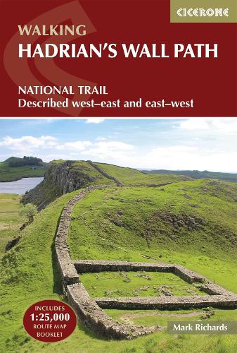
Hadrian's Wall Path :National Trail: Described west-east and east-west
paperback
Published:
2 June, 2025
Popular Books by Mark Richards
View All Books by Mark Richards


Description
Walk through history on the Hadrian’s Wall Path, a remarkable 135km (84-mile) National Trail following the line of the ancient Roman frontier across northern England, from Bowness-on-Solway in Cumbria to Wallsend, Newcastle. Accessible to first-time long-distance walkers yet equally rewarding for seasoned hikers, the trail winds through rolling farmland, wild moorland, and remarkable Roman sites, including ancient forts, milecastles, and exposed stretches of the Wall itself.
Designed to help you get the most from every mile, this Cicerone guidebook features detailed route descriptions covering the entire trail in both directions, west to east or east to west, plus an optional extension to South Shields to complete the coast-to-coast. An accompanying OS 1:25,000 map booklet, with full route line clearly marked, enables easy and accurate navigation throughout your journey.
- The route is divided into 10 manageable stages, each supported by detailed mapping, distance information and route description, so you're always prepared for what lies ahead on Hadrian's Wall
- Practical planning information, such as accommodation listings in key centres like Carlisle, Newton and Hexham, alternative walking schedules and route options, helps you adapt the walk to your own pace
- Public transport options are listed for every stage, including trail diversions to Haltwhistle, Bardon Mill and Corbridge stations, making it easy for section hikers to devise an itinerary that suits their needs
- Downloadable GPX files provide a simple digital navigation option for use on smartphone apps
- Alongside navigation, the guide enriches your journey with authoritative context on world-class archaeological sites, including Birdoswald, Housesteads, Vindolanda, and the dramatic crags of Steel Rigg, helping you understand the significance of this historic landscape as you walk
The Hadrian’s Wall Path invites a quieter kind of adventure — one of steady footsteps, open views, and moments of connection with the landscape’s long history. With this guidebook, you can explore Britain's Roman frontier at your own pace, supported by clear guidance and a complete set of navigational tools.
More Details
| Type | Book |
|---|---|
| ISBN13 | 9781786311504 |
| ISBN10 | 178631150X |
| Number Of Pages | 248 |
| Item Weight | 350 g |
| Product Dimensions | 116 x 172 x 14 mm |
| Publisher / Reseller | Cicerone Press |
| Format | paperback |
| Edition | 4th Revised edition |
GoodReads Reviews
Author's Bio
In 1980 Mark Richards began his three-part guide to the Peak District for Cicerone Press, and in 1987, with Chris Wright, wrote a guide to walking around the former county of Westmorland. He now lives in Cumbria and, after 14 years' dedicated research, has completed his series of Lakeland Fellranger guides covering the entire region.