Popular Books by A-Z Maps
View All Books by A-Z Maps

Middlesbrough A-Z Street Atlas (paperback)
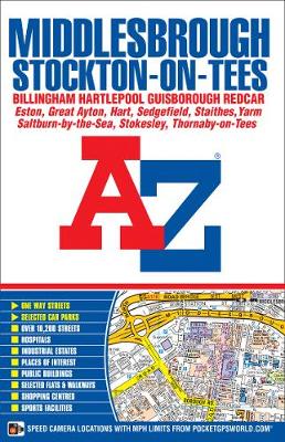
Middlesbrough A-Z Street Atlas (paperback)
paperback
Published:
19 December, 2014

Description
This AZ map of Middlesbrough, Stockton-on-Tees, Billingham, Hartlepool, Guisborough and Redcar is a full colour, paperback street atlas featuring 166 pages of mapping which extends to cover:
*Hart Station
- Seaton Carew
- Marske-by-the-Sea
- Saltburn-by-the-Sea
- Brotton
- Staithes
- Moorsholm
- Great Ayton
- Stokesley
- Kirklevington
- Durham Tees Valley Airport
- Long Newton
- Thornaby-on-Tees
- Stillington (inset)
- Wynyard Village
- Elwick
- There is also separate coverage of Sedgefield.
Postcode districts, one-way streets, safety camera locations with maximum speed limits and the North York Moors National Park boundary are featured on the mapping.
Also included is a double-page postcode map of the atlas area.
The index section lists streets, selected flats, walkways and places of interest, place, area and railway stations. There is a separate list of hospitals and hospices covered by this atlas.
More Details
| Type | Book |
|---|---|
| ISBN13 | 9781782570530 |
| ISBN10 | 1782570535 |
| Number Of Pages | 224 |
| Item Weight | 250 g |
| Product Dimensions | 121 x 190 x 10 mm |
| Publisher / Reseller | HarperCollins Publishers |
| Format | paperback |
| Edition | New Eighth edition |
Author's Bio
Britain's leading street map publisher providing cartographic services, digital data products and paper mapping publications (including Street Atlases, Visitors Guides, Great Britain Road Atlases and The Adventure Atlas).