Ireland: Mapping the Island
Ireland: Mapping the Island
hardback
Published:
2 October, 2025
Popular Books by Joseph Brady
View All Books by Joseph Brady


Description
Shortlisted for the An Post Irish Book Awards History Book of the Year
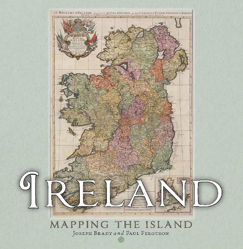
Maps allow us to see how the world is organised spatially and show us relationships which cannot be understood from simply reading a text. This magnificent book highlights a vast selection of maps that range across the centuries and cover every part of the island, shedding light on the history and development of Ireland.
The themes are many and varied, from conquest and colonisation, the management of the landscape, natural resources, meeting the needs of tourists, transport, the growth of urban centres as well as exploring how others saw Ireland, and much more besides. Carefully selected by two noted map experts, this highly visual book tells the story of Ireland in a unique and stimulating way.
Prizes
Short-listed for An Post Irish Book Awards History Book of the Year 2025
More Details
| Type | Book |
|---|---|
| ISBN13 | 9781780279640 |
| ISBN10 | 1780279647 |
| Number Of Pages | 272 |
| Item Weight | 1713 g |
| Product Dimensions | 246 x 250 x 35 mm |
| Publisher / Reseller | Birlinn General |
| Format | hardback |
Media Reviews
'a pleasure... the narrative is fluent, the production values are high and the reader is guided confidently from medieval sketches to the great surveys of the 19th century... a generous and visually appealing introduction to the country's cartographic heritage'
-- Conor Skehan * Sunday Independent *'A visual feast, a perfect fusion of geography and history'
* Irish Independent *'There's no doubting the scholarly rigour of this production, which reflects maps' many distinctive styles and strategies... an invite to the imagination from long before Google Maps'
* Irish Times *'Both scholarly and accessible at the same time . . . the best general book dealing with Irish maps of the period covered that I've seen. It's a handsome hardback production'
* EastWest Mapping *'A celebration of the maps of Ireland produced over the centuries'
* RTE *'These days we take maps, and the knowledge of the real world that they display, very much for granted. This was always the case as this marvellous compendium of Ireland’s history as evidenced in cartography reveals... It is the... details on all the maps in this book that make its pages such a delight'
* Irish Catholic *'Magnificent'
* Books Ireland *'This is a truly magnificent tome, a full bells-and-whistles production that’s beautifully put together. It would make a superb gift for the keen geography fan, the history buff, in fact anyone at all who has a curious mind and an interest in our fair land'
* Connaught Telegraph *'A breathtaking book'
* Meath Chronicle *'A beautiful book'
* Galway FM *'Charting centuries of Ireland’s past through cartography, Ireland: Mapping the Island by Joseph Brady and Paul Ferguson — a Hodges Figgis Book of the Year and An Post Irish Book Awards finalist — reveals the island’s history, power struggles and evolving identity through its extraordinary maps'
-- Grace Gourlay * Geographical Magazine *GoodReads Reviews
Author's Bio
Joseph (Joe) Brady taught in the school of Geography at University College Dublin. He has been writing about the development of Dublin for many years and is one of the leading experts in the field.
Paul Ferguson is Map Librarian at Trinity College Library, Dublin.