Collins Large World Wall Laminated Map (70 x 91.5 cm) :Laminated Map with Flags, Perfect for Classroom, Office and Home
Collins Large World Wall Laminated Map (70 x 91.5 cm) :Laminated Map with Flags, Perfect for Classroom, Office and Home
map
Published:
29 August, 2024
Popular Books by Collins Maps
View All Books by Collins Maps


Description
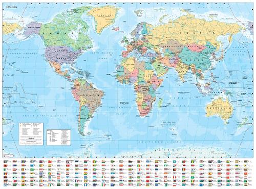
Fully updated world map to include the latest political changes. The map contains politically coloured mapping which shows each country and their capital city, major roads, and cities and towns clearly. Also included are national flags, key statistics for every country and inset maps of the polar regions.
The map is printed on high quality paper and comes rolled in a fully recyclable cardboard box – ideal as a poster for any classroom, bedroom or office wall.
Area of coverage:
All of the world, centred on the Greenwich Meridian, and including maps of the North and South Pole regions.
Scale:
1:30 000 000; 1 cm to 300 km; 1 inch to 480 miles
Size:
700 x 915 mm (27.5 x 36 inches)
Other versions available:
Paper flat map (ISBN 978-0-00-849255-7)
More Details
| Type | Book |
|---|---|
| ISBN13 | 9780008712587 |
| ISBN10 | 0008712581 |
| Item Weight | 20 g |
| Product Dimensions | 915 x 700 x 50 mm |
| Publisher / Reseller | HarperCollins Publishers |
| Format | map |
GoodReads Reviews
Author's Bio
Explore the world through accurate and up-to-date mapping.