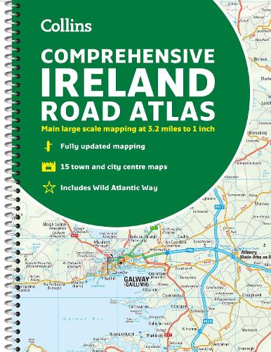
Comprehensive Road Atlas Ireland
Comprehensive Road Atlas Ireland
other
Published:
2 March, 2023
other
Published:
2 March, 2023
Standard worldwide delivery by
Thu, June 18 - Tue, June 23
Order within
0
Popular Books by Collins Maps
View All Books by Collins Maps


Description
Clear, detailed road atlas of Ireland in a handy A4 spiral-bound format.
This comprehensive, general purpose road atlas is ideal for both business and pleasure.
Highlights include:
- Clear mapping at a scale of 3.2 miles to 1 inch, which is useful for navigation
- An additional 9 miles to 1 inch route planning map
- Places of interest section with information and photographs
- A range of fully indexed town and city centre maps, including: Bangor, Belfast, Cork, Dublin, Limerick, Lisburn, Londonderry (Derry) and Newtownabbey
This updated edition boasts road mapping packed with detail. There is a colour classified road network that also shows toll roads. Blue Flag and Green Coast beaches are shown along with tourist information centres and a wide range of tourist attractions. There is also comprehensive information for visitors to Belfast, Cork, Dublin and Limerick.
The perfect companion for anyone visiting Ireland.
More Details
| Type | Book |
|---|---|
| ISBN13 | 9780008412814 |
| ISBN10 | 0008412812 |
| Number Of Pages | 160 |
| Item Weight | 500 g |
| Product Dimensions | 215 x 297 x 8 mm |
| Publisher / Reseller | HarperCollins Publishers |
| Format | other |
| Edition | New edition |
See More +
GoodReads Reviews
Author's Bio
Explore the world through accurate and up-to-date mapping.