Discovering Edinburgh Illustrated Map :Ideal for Exploring
Discovering Edinburgh Illustrated Map :Ideal for Exploring
map
Published:
6 June, 2024
Popular Books by Dominic Beddow
View All Books by Dominic Beddow
Description
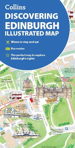
This brand new edition retains the delightful water-colour mapping, with individual paintings of all the main sights and landmarks.
This brand new edition retains the delightful water-colour mapping, with individual paintings of all the main sights and landmarks.
Popular areas at larger scale, hundreds of shops, restaurants, cafés and bars, comprehensive travel information and index.
This map includes:
• Large-scale plans of the Castle, Royal Mile, Botanic Gardens, Leith and Newington
• Shop-by-shop street maps of Princes Street, George Street, Victoria Street and the Grassmarket
• Railway stations, bus routes, taxi ranks and car parks
• Historical and contemporary anecdotes
• Suggestions for day trips out of the city
• Comprehensive index
Area of coverage:
Covers the centre of Edinburgh from Inverleith Park in the north to The Meadows in the south, and from the Scottish National Gallery of Modern Art in the west to the Palace of Holyroodhouse in the east.
The perfect companion to Edinburgh for visitors and locals alike.
More Details
| Type | Book |
|---|---|
| ISBN13 | 9780008663476 |
| ISBN10 | 0008663475 |
| Number Of Pages | 2 |
| Item Weight | 50 g |
| Product Dimensions | 102 x 198 x 4 mm |
| Publisher / Reseller | HarperCollins Publishers |
| Format | map |
Media Reviews
“a wonderful picture of what the city has to offer. It is full of intriguing locations and is as much a delight to read as it is to use.”
Alexander McCall Smith
Author's Bio
Dominic Beddow produces informative maps of cities from Amsterdam to Zanzibar. The hand illustrated Collins maps include London, Glasgow and Edinburgh. The maps are checked on foot, bicycle or scooter and then peppered with useful description, whimsy, humour and historical anecdote.