Hadrian’s Wall Path National Trail Map
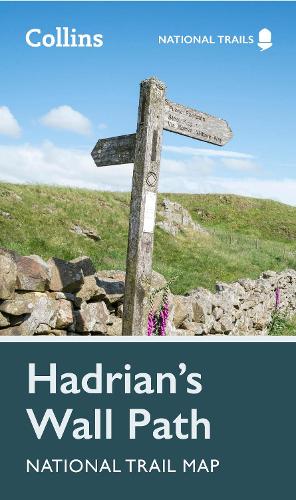
Hadrian’s Wall Path National Trail Map
map
Published:
16 February, 2023
map
Published:
16 February, 2023

Standard worldwide delivery by
Thu, August 6 - Tue, August 11
Order within
0
Popular Books by Collins Maps
View All Books by Collins Maps
Description
Perfect guide and map for planning your adventure along Hadrian’s Wall.
Highlights of this Planning Map include:
- More than 20 highlighted places of interest with detailed descriptions and attractive photographs, including: the Vindolanda archaeological site, Chester’s Roman fort, and Steel Rigg viewpoint.
- A comprehensive index to more than 400 cities, towns and villages
- A clear, visible route plotted across the map
- Advice on safety and security when travelling along the route, as well as the countryside code and the code of conduct
Part of the National Trail network, this long-distance footpath covers 84 miles (135 km) along the line of Hadrian's Wall from coast-to-coast. Starting in Wallsend in Newcastle and ending in Bowness-on-Solway, this path weaves through beautiful countryside, encountering historic remains of Roman forts and milecastles, and splendid bridges. A suggested walking itinerary makes it easy for users to plan their journey along this popular route.
More Details
| Type | Book |
|---|---|
| ISBN13 | 9780008602987 |
| ISBN10 | 0008602980 |
| Item Weight | 60 g |
| Product Dimensions | 115 x 198 x 4 mm |
| Publisher / Reseller | HarperCollins Publishers |
| Format | map |
See More +
Author's Bio
Explore the world through accurate and up-to-date mapping.