Renaissance Galway :delineating the seventeenth-century city - Irish Historic Towns Atlas
Renaissance Galway :delineating the seventeenth-century city - Irish Historic Towns Atlas
paperback
Published:
1 September, 2019
Popular Books by Paul Walsh
View All Books by Paul Walsh
Description
More Details
| Type | Book |
|---|---|
| ISBN13 | 9781911479079 |
| ISBN10 | 1911479075 |
| Number Of Pages | 110 |
| Item Weight | 466 g |
| Product Dimensions | 240 x 240 x 11 mm |
| Publisher / Reseller | Royal Irish Academy |
| Format | paperback |
Media Reviews
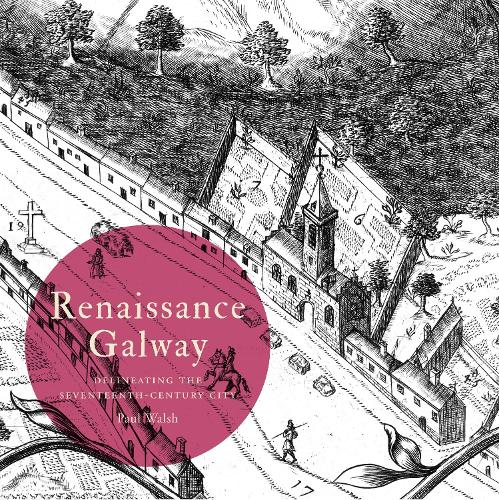
'Paul Walsh has selected 38 sections of the map, blown them up, and accompanied each with a wonderfully informative explanatory essay, and in doing so has presented us with a remarkable visual tour of the urban landscape of the period and also various coats of arms, allegorical images, and aspects of everyday life. [...] very highly recommended'. https://www.advertiser.ie/galway/article/110522/balls-bridge-1685 -- Tom Kenny * Balls Bridge, 1685 *
'38 chapters, or exciting avenues of extra knowledge, backed up by amazing large illustrations from sections of the map, insert even more life into this amazing piece of urban cartography. The amount of research undertaken by the author is immense'. -- Peadar O'Dowd * Putting Galway's past and future heritage on the map *
'It is a remarkable and wonderful piece of work... There is much to savour here'. -- Joe Culley * Book Worm *
Author's Bio
Paul Walsh has spent his career working in Irish archaeology and has a passionate interest in the history and archaeology of his native city, Galway. His publications include Discover Galway (2001) and he is joint author with Jacinta Prunty of Galway c. 1200 to c. 1900: from medieval borough to modern city (2015) and Irish Historic Towns Atlas, no. 28, Galway/Gaillimh (2016).