When you buy a used copy YOU SAVE
0.44Kg of CO2
111 litre(s) of Water
0.0067 Tree(s)
1 book donated to global literacy projects
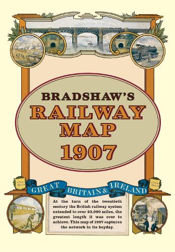
Bradshaw's Railway Folded Map 1907
Bradshaw's Railway Folded Map 1907
map | English
Published:
21 November, 2011
map | English
Published:
21 November, 2011
Standard worldwide delivery by
Tue, June 16 - Fri, June 19
Order within
0

Condition:
USED
$5.64
RRP
$13.33
You save $7.69 (58%)
Available
1
in stock
FREE Returns within 30 days
Popular Books by George Bradshaw
View All Books by George Bradshaw


![Bradshaw's Invalid's Companion to the Continent [electronic Resource]](https://d32vymxhv9fq6b.cloudfront.net/images/books/medium/97810/9781014573919.jpg)
![Bradshaw's Continental [afterw.] Monthly Continental Railway, Steam Navigation & Conveyance Guide. June 1847 - July/oct. 1939. Special Ed](https://d32vymxhv9fq6b.cloudfront.net/images/books/medium/97810/9781021194091.jpg)

Description
At the turn of the 20th century the rail network extended to over 23,000 miles, very nearly the circumference of the world the greatest length it was ever to achieve. Some urban routes had closed and later, hundreds of rural lines and stations succumbed to the Beeching axe. This map shows the network in its heyday before the decline commenced.
More Details
| Type | Book |
|---|---|
| ISBN13 | 9781908402134 |
| ISBN10 | 190840213X |
| Item Weight | 120 g |
| Product Dimensions | 148 x 210 x 12 mm |
| Publisher / Reseller | Bloomsbury Publishing PLC |
| Format | map |
See More +
GoodReads Reviews
Author's Bio
George Bradshaw (1801-1853) was an English cartographer, printer and publisher. He is most famous for developing a series of railway timetables and guides. The books became synonymous with its publisher so that, for Victorians and Edwardians alike, a railway timetable was 'a Bradshaw'. After his death Punch magazine said of Bradshaw's labours: 'seldom has the gigantic intellect of man been employed upon a work of greater utility.'