Philip's Navigator Scotland :The Best of Scotland: Spiral - Philip's Road Atlases
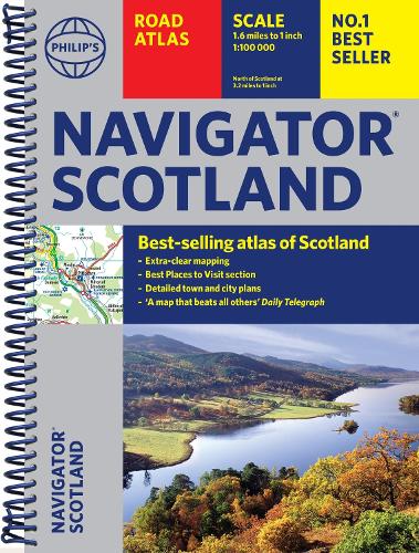
Philip's Navigator Scotland :The Best of Scotland: Spiral - Philip's Road Atlases
spiral bound
Published:
2 January, 2025

Popular Books by Philip's Maps
View All Books by Philip's Maps

Description
Philip's Navigator Scotland is the UK's best-selling atlas of Scotland. The Navigator brand is famous for the UK's clearest mapping and superb extra detail - essential for the motorist, whether for business or pleasure - and all with a fully updated section on the best Scotland has to offer.
'A map that beats all others.' - The Daily Telegraph
'Scale, accuracy and clarity are without parallel.' - Driving Magazine
'No.1 in the UK for clear maps.' - Independent research survey
- Exceptional clarity at a scale of 1.5 miles to 1 inch = 1:100,000 (3 miles to 1 inch = 1:200,000 for Northern Scotland)
- No other road atlas of Scotland can provide this level of detail and touring information
- Invaluable 'Best Places to Visit' section, including heritage spots, spectacular sights and the best walks, including the Southern Upland, West Highland, Great Glen and Speyside Ways
- Key town-centre maps fully indexed for easy navigation
- Exceptional road detail, from motorways to country lanes, with every junction, roundabout and slip-road shown
- Packed with hundreds of individually named farms, houses and hamlets, alongside all the key heritage and cultural sites
- Hard-wearing and practical A4 format with spiral binding
Navigator Scotland offers so much more than a mere road map: hundreds of individually named farms, houses and hamlets, airports, airfields, stations, ferries, canals, harbours, tourist information centres, and a wide range of places of interest ranging from castles to chapels. Every element is clearly indexed for easy use and includes indexed town plans of all the major regional centres. Added to all that is a guide to Scotland's many leisure facilities and listings of a wide variety of activities from abseiling to yachting.
The atlas is perfect for touring with its large scale and wealth of travel information. The exceptional detail also makes the atlas ideal for local business use.
More Details
| Type | Book |
|---|---|
| ISBN13 | 9781849077033 |
| ISBN10 | 1849077037 |
| Number Of Pages | 144 |
| Item Weight | 420 g |
| Product Dimensions | 222 x 296 x 8 mm |
| Publisher / Reseller | Octopus Publishing Group |
| Format | spiral bound |
Media Reviews
Very useful as we adventurer on some of the NC500 route and explored Scotland. -- Customer review * Amazon *
Well laid out lots of information easy to read -- Customer review * Amazon *
Maps places that other road maps miss. -- Customer review * Amazon *
GoodReads Reviews
Author's Bio
Philip's has been at the forefront of creating maps and atlases since 1834. Whether a local street map or a fact-packed World Atlas, we use the most up-to-date technology, expertise and our global network to ensure our customers have all the information they need.