Pembrokeshire Coast Path Map Booklet :1:25,000 OS Route Mapping
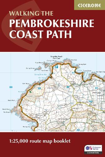
Pembrokeshire Coast Path Map Booklet :1:25,000 OS Route Mapping
paperback
Published:
28 February, 2024
Popular Books by Dennis Kelsall
View All Books by Dennis Kelsall
Description
A booklet of all the mapping needed to walk the Pembrokeshire Coast Path National Trail between Amroth near Tenby and St Dogmaels by Cardigan. Covering 290km (180 miles) and over 10,500m of ascent, this trail takes around 2 weeks to complete.
- The full route is shown on 1:25,000 OS maps
- The map booklet can be used to walk the trail in either direction
- Sized to easily fit in a jacket pocket or rucksack
- The relevant extract from the OS Explorer map legend is included
- High tide and military range closure alternate routes are provided
- An accompanying Cicerone guidebook – Walking the Pembrokeshire Coast Path is also available, which includes a copy of this map booklet
More Details
| Type | Book |
|---|---|
| ISBN13 | 9781786312099 |
| ISBN10 | 1786312093 |
| Number Of Pages | 80 |
| Item Weight | 100 g |
| Product Dimensions | 116 x 172 x 5 mm |
| Publisher / Reseller | Cicerone Press |
| Format | paperback |
| Edition | 2nd Revised edition |
Author's Bio
Dennis and Jan Kelsall published their first Cicerone title in 1995 and have since written around 35 guides to some of Britain's most popular walking areas: they have also become regular contributors to various outdoor magazines. Their enjoyment of the countryside extends far beyond a love of fresh air, open spaces and scenery: over the years Dennis and Jan have developed wider interests in the environment, geology and wildlife, as well as an enthusiasm for local history, which so often provides clues to interpreting the landscape.