The South Downs Way Map Booklet :1:25,000 OS Route Mapping
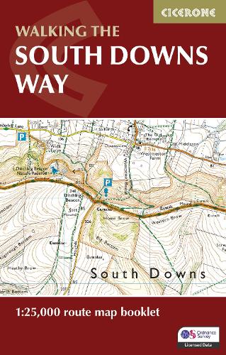
The South Downs Way Map Booklet :1:25,000 OS Route Mapping
paperback
Published:
28 June, 2023
Popular Books by Kev Reynolds
View All Books by Kev Reynolds


Description
A booklet of all the mapping needed to complete the 158km (100 mile) South Downs Way National Trail. The route crosses the South Downs National Park to link Eastbourne with Winchester and is an ideal option for those new to long-distance walking; it is also suitable for riders.
- The full route line is shown on 1:25,000 OS maps
- The map booklet can be used to walk (or ride) the trail in either direction
- Sized to easily fit in a jacket pocket
- The relevant extract from the OS Explorer map legend is included
- An accompanying Cicerone guidebook – The South Downs Way is also available, which includes a copy of this map booklet
More Details
| Type | Book |
|---|---|
| ISBN13 | 9781786311658 |
| ISBN10 | 1786311658 |
| Number Of Pages | 64 |
| Item Weight | 70 g |
| Product Dimensions | 106 x 166 x 8 mm |
| Publisher / Reseller | Cicerone Press |
| Format | paperback |
| Edition | 2nd Revised edition |
GoodReads Reviews
Author's Bio
Kev Reynolds was a freelance writer, photojournalist and lecturer. A prolific compiler of guidebooks, his first title for Cicerone Press (Walks & Climbs in the Pyrenees) appeared in 1978; he later produced many more titles for the same publisher. A member of the Outdoor Writers' Guild, the Alpine Club and Austrian Alpine Club, his passion for mountains and the countryside inspired a lifetime's activity, and he regularly travelled throughout Britain to share that enthusiasm through his lectures. Sadly, Kev passed away in 2021. He will be remembered fondly by all who knew him and by many more he inspired through his writing and talks.