Antarctic Atlas :New Maps and Graphics That Tell the Story of A Continent
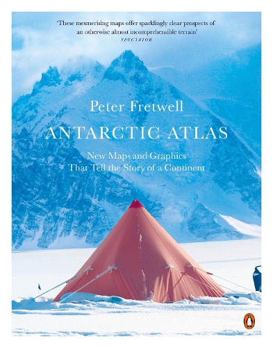
Antarctic Atlas :New Maps and Graphics That Tell the Story of A Continent
paperback
Pre-Order Published On:
3 September, 2026
Popular Books by Peter Fretwell
View All Books by Peter Fretwell

Description
A leading cartographer from the British Antarctic Survey maps the continent in ways never seen before, revealing a landscape as alien as it is vital to our very existence
One of the least-known places on the planet, the only continent on earth with no indigenous population, Antarctica is a world apart. From a leading cartographer with the British Antarctic Survey, this new collection of maps and data reveals Antarctica as we have never seen it before.
This is not just a book of traditional maps. It measures everything from the thickness of ice beneath our feet to the direction of ice flows. It maps volcanic lakes, mountain ranges the size of the Alps and gorges longer than the Grand Canyon, all hidden beneath the ice. It shows us how air bubbles trapped in ice tell us what the earth's atmosphere was like 750,000 years ago, proving the effects of greenhouse gases. Colonies of emperor penguins abound around the coastline, and the journeys of individual seals around the continent and down to the sea bed in search of food have been intricately tracked and mapped. Twenty-nine nations have research stations in Antarctica and their unique architecture is laid out here, along with the challenges of surviving in Antarctica'sunforgiving environment.
Antarctica is also the frontier of our fight against climate change. If its ice melts, it will swamp almost every coastal city in the world. Antarctic Atlas illustrates the harsh beauty and magic of this mysterious continent, and shows how, far from being abstract, it has direct relevance to us all.
More Details
| Type | Book |
|---|---|
| ISBN13 | 9780141985473 |
| ISBN10 | 014198547X |
| Number Of Pages | 208 |
| Item Weight | 200 g |
| Product Dimensions | 189 x 246 x 15 mm |
| Publisher / Reseller | Penguin Books Ltd |
| Format | paperback |
Media Reviews
These mesmerising maps offer sparklingly clear prospects of an otherwise almost incomprehensible terrain—The Spectator
Tells the story of Antarctica in maps and shows the continent in ways never seen before—Cambridge Independent
A cartographer and scientist with the British Antarctic Survey, Fretwell has created 70 new maps each revealing different aspects of the icy continent. We learn the locations of the "pole of ignorance", the world's driest place, and the largest penguin colonies, but also about the human history and politics of the region and - alarmingly - what Antarctica might look like once all the ice is gone.—Financial Times
Shows Antarctica in wonderful detail ... Peter Fretwell tells the tale of Antarctica through a collection of carefully constructed maps setting out the continent's geology, people and nature—Gege Li, New Scientist
A collection of maps and data from a leading cartographer seen in a new and fresh way ... really informative—Sandra Pereira, Portugal News
Author's Bio
Peter Fretwell is an award-winning cartographer and leading scientist at the British Antarctic Survey. He pioneered the use of satellite imagery to find and monitor polar wildlife, a project that has led to him discovering almost half of the world's emperor penguin colonies. He is a fellow of the Royal Geographical Society and has completed four field seasons in Antarctica. He lives near Cambridge with his wife and family.