Yorkshire Dales National Park Pocket Map :The Perfect Guide to Explore This Area of Outstanding Natural Beauty
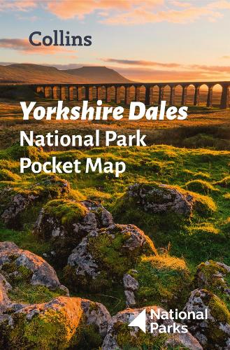
Yorkshire Dales National Park Pocket Map :The Perfect Guide to Explore This Area of Outstanding Natural Beauty
map
Published:
4 March, 2021
Popular Books by National Parks UK
View All Books by National Parks UK

Description
Detailed mapping and visitor information to the National Park along with a selection of photographs. Map at a scale of 1:140 000 (1cm to 1.40km, 2.2 miles to 1 inch).
This small map with additional text and photographs gives a great overview of the Yorkshire Dales National Park, and is the perfect companion for exploring this beautiful area of Northern England.
- Clear, detailed mapping
- Key park, tourist and travel information
- Ideal for planning visits to the National Park
- Index to help locate and plan your trip
This and the Yorkshire Dales Park Rangers Favourite Walks (ISBN: 9780008462659) are the perfect companions for exploring this superb walking area of England.
More Details
| Type | Book |
|---|---|
| ISBN13 | 9780008439248 |
| ISBN10 | 0008439249 |
| Number Of Pages | 1 |
| Item Weight | 40 g |
| Product Dimensions | 90 x 140 x 14 mm |
| Publisher / Reseller | HarperCollins Publishers |
| Format | map |
Author's Bio
There are 15 National Parks in the United Kingdom and each one is looked after by its own authority. We work together as National Parks UK. There are 10 National Parks in England, 3 in Wales and 2 in Scotland, they are: England – Broads, Dartmoor, Exmoor, Lake District, New Forest, Northumberland, North York Moors, Peak District, Yorkshire Dales, and South Downs. Wales – Brecon Beacons, Pembrokeshire Coast, and Snowdonia Scotland – Cairngorms and Loch Lomond & the Trossachs Explore the world through accurate and up-to-date mapping.