Southampton A-Z Street Atlas :Accurate Street Map for Easy Navigation
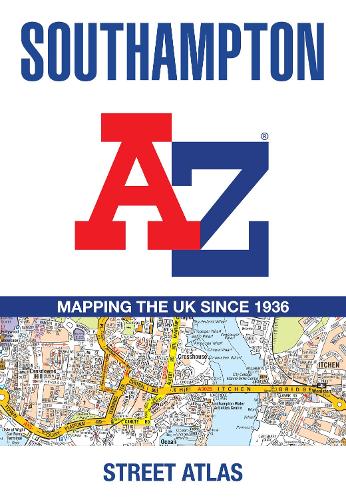
Southampton A-Z Street Atlas :Accurate Street Map for Easy Navigation
paperback
Published:
22 May, 2025
Popular Books by A-Z Maps
View All Books by A-Z Maps


Description
Printed in full-colour, paperback format, this atlas contains 50 pages of continuous street mapping.
The main mapping extends beyond central Southampton at a scale of 4 inches to 1 mile, featuring postcode districts, one-way streets, park and ride sites, and safety camera locations. Areas covered include:
• Eastleigh
• Fawley
• Hythe
• Romsey
• Southampton Airport
• Totton
• Chandler's Ford
• Hamble-le-Rice
• Hedge End
• North Baddesley
The large-scale street map of Southampton city centre – at a scale of 8 inches to 1 mile – includes:
• Postcode map of the Southampton area
• Road map of the Southampton area
• New Forest National Park boundaries
A comprehensive index lists streets, selected flats, walkways and places of interest, place, area and station names. Additional healthcare (hospitals, walk-in centres and hospices) are indexed as well.
More Details
| Type | Book |
|---|---|
| ISBN13 | 9780008730888 |
| ISBN10 | 0008730881 |
| Number Of Pages | 80 |
| Item Weight | 120 g |
| Product Dimensions | 149 x 215 x 5 mm |
| Publisher / Reseller | HarperCollins Publishers |
| Format | paperback |
| Edition | Tenth edition |
Author's Bio
Britain’s leading street map publisher providing cartographic services, digital data products and paper mapping publications (including Street Atlases, Visitors Guides, Great Britain Road Atlases and The Adventure Atlas).